Why Beachwalking?
It seems obvious: just take a stroll along a nearby beach, right? Well yes, but like a bush track network there are sometimes ways of linking beaches and headlands to turn a stroll into a journey. And where the tides allow access around headlands on rock platforms the opportunities are boundless. Combine that with public transport if you don't like retracing (and I don't), and you have the basis for a full day's experience.
These conditions come together in the northern part of the Illawarra, where apart from diversions at Coalcliff and crossing the Sea Cliff bridge, it's possible to traverse well over 20km of stunning shoreline at low tide,
and return by the adjacent rail network.

Click for larger copy
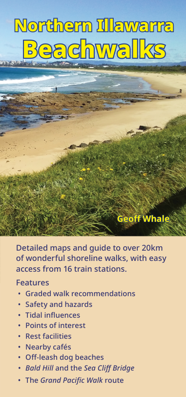
Northern Illawarra Beachwalks
is a pocket-sized booklet
describing shoreline access between Stanwell Park and Wollongong, emphasising convenient public transport links.
It has 9 detailed maps with walking routes, hazards and points of interest.
The guide includes information about safety and tides, recommended walks and transport options.
It retails for $6, or $5 from local outlets in the Illawarra region.
You can order below (PayPal only), posted to your PayPal address. See also information for resellers.
Pick up a copy at Collins Booksellers Thirroul or Bushcraft Equipment, 29 Stewart St Wollongong. Travellers from Sydney should drop into the Southern Gateway Centre on the M1 at Bulli Tops for the same deal, and much more.
From north to south, the maps cover
- N1 Stanwell Park, includes Otford, Bald Hill, and escarpment access
- N2 Coalcliff to Clifton, includes the Sea Cliff bridge and (hazardous) lookout
- N3 Scarborough to Wombarra, includes the historic but difficult Ghost Pools Walk
- C1 Coledale to Austinmer, best low-tide platforms
- C2 Thirroul to Bulli
- C3 Woonona to Bellambi
- S1 Corrimal to Towradgi, including Bellambi Lake
- S2 Fairy Meadow to North Wollongong, including Puckeys Estate Nature Reserve
- S2 Wollongong to Coniston, including Flagstaff Hill and the Blue Mile

N1: Stanwell Park
sample map
This is a low-resolution copy, click on it for the full SVG (vector) format, about 6Mb, intended to be viewed at about 200mm width.
The Grand Pacific Walk (shown as  ) runs the length of the Illawarra,
mostly on a shared bike/predestrian pathway.
At the northern end it links to Bald Hill via the newly constructed NPWS Bald Hill Track and then onto the Royal National Park.
Beachwalk routes link to the GPW where rocky cliffs prevent contiguous shoreline access.
) runs the length of the Illawarra,
mostly on a shared bike/predestrian pathway.
At the northern end it links to Bald Hill via the newly constructed NPWS Bald Hill Track and then onto the Royal National Park.
Beachwalk routes link to the GPW where rocky cliffs prevent contiguous shoreline access.

S1: Bellambi to Towradgi
sample map
Closer to Wollongong there are combinations of beach and other interesting walks.
Bellambi Lagoon is a haven for waterbirds, and along with dune tracks through remnant coastal vegetation, offers a rich variety of walking experiences.
From Towradgi Point the beach stretches for 2.5km north to Bellambi Point and for 3.6km south to North Wollongong. That's over 6km of pristine beach with just one low headland.
Buy now with PayPal
Select the quantity required. Booklets will be posted to the address held by PayPal, usually the next business day. No personal or financial details are held on this website.
GPX tracks
If you've installed the free OSMAnd mapping app and the NSW base map, you can soon add these files to My Tracks. OSMAnd works offline. Available mid April.
SVG samples
Copies of the N1 and S1 sample maps above, in full SVG format (zipped, 4Mb)
Reseller orders
Email sales@grwpub.info with your name, phone, business name, address and quantity
| Local (Illawarra) retailers | Elsewhere | |
|---|---|---|
| RRP inc GST | $5 | $6 |
| Order qty 3 | $10 COD | N/A* |
| Order qty 5 | $15 COD | N/A* |
| Order qty 10+ | 40% off RRP, 60 day invoice | 40% off RRP, 60 day invoice |
| Order qty 40+ | 45% off RRP, 60 day invoice | 45% off RRP, 60 day invoice |
| DL display case, holds 10 booklets | free with first order of 10+, subject to availability | N/A |
* try distributors ABC Maps or Envirobook