Walking, Mapping, Publishing
Services: preparing maps and associated text for walking tracks and routes in southern Sydney, the Illawarra and South Coast. Early publications used data licensed from Geoscience Australia, rendered into EPS for print; current technology is OpenStreetMap data and rendering, overlaid with new routes and information. Products are paper, and online through free apps.
Principal: Geoff Whale, retired academic and functional analyst at UNSW. Now lives in Bulli in the Illawarra, south of Sydney.
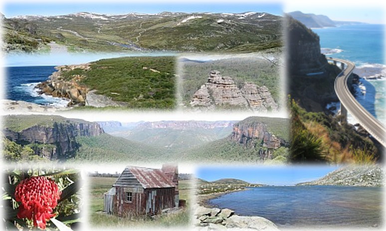
clockwise spiral from top: Main Range from Charlotte Pass, Kosciuszko NP • Sea Cliff Bridge, Clifton NSW • Lake Cootapatamba, KNP • Four Mile Hut, KNP, sadly lost in the 2020 fires • waratah, Royal NP • Blue Gum Forest from Govetts Leap, Blue Mountains NP • The Waterrun, Royal NP • sandstone pagodas, Munghorn NP, central west NSW
Projects and Products.
Family Bushwalks in the Snowy Mountains
128-page guide to 22 day walks in Kosciuszko National Park. Second edition published in 2008, now almost out of print.

Beachwalking
Guides to walking routes that traverse multiple beaches connected by headlands, or better, rock platforms. Northern Illawarra Beachwalks by Train is in preparation.
Wolli Creek Track mapping
Responsible for mapping the route (and some trailblazing through privet and lantana to complete the section from Bardwell Park to Bexley North). A detailed A3 brochure with map and walk planner is available.
Ruwenzori
This popular trainstay property near Mudgee has many walking tracks. The original map prepared in 2006 is still available.
SVG fun
using the same format as is best for representing maps (SVG), have a look at these animations of the sometimes strange results of preference deals in the 2013 elections for the Senate.